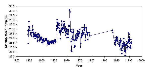
Any analysis of the temperature and precipitation records for Kosrae must be prefaced with the caution that the record is not complete. The records of temperature and precipitation for Kosrae have gaps ranging from one month up to a six year gap between 1979 and 1986. Between 1973 and 1986 there was no year for which summary records exist for all twelve months. The record starts with five months of data in 1954 and continues up to and including 1995.
The temperature record shows a monthly mean low temperature of 25.1 Celsius, an average 27.2 Celsius, and a monthly mean high temperature of 30.1 Celsius. Sixty-three percent of the monthly mean temperatures fell within 0.8 degrees Celsius of the mean. There is no pattern of seasonal temperature change, the difference in the mean monthly temperature between any two months in the year is less that 0.3 Celsius. The temperature data does not show any trend in temperature, revealing instead indications of instrument and measurement errors on a scale that would hide any trend data.
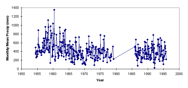
The precipitation data also has gaps in it, including missing months and the large 1979 to 1985 gap that the temperature data possesses. The record starts with five months of data in 1954 and continues up to and including 1995.
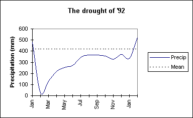
The precipitation record shows a monthly mean low precipitation of 29 millimeters in February 1992. This marked the start of a drought on Pohnpei, with a twelve month period of below average rainfall from February 1992 to February 1993.
The monthly mean precipitation is 420 millimeters, and a monthly mean high precipitation of 1351 millimeters fell in April 1960. 1351 millimeters (over fifty inches) exceeds the typically annual rainfall in the Midwestern area of North America. Sixty-three percent of the monthly mean precipitation fell within 190 millimeters of the mean.
 Statistics for the total annual
precipitation are plagued by missing data. While some years are complete for all 12
months, on average there are only ten months of data per year. There are years with no
data, and years with only one month of data. Years in which there was no data have been
excluded. In order to perform some form of analysis, years for which partial data exists
have had their mean precipitation for the existing months multiplied out over a 12 month
period.
Statistics for the total annual
precipitation are plagued by missing data. While some years are complete for all 12
months, on average there are only ten months of data per year. There are years with no
data, and years with only one month of data. Years in which there was no data have been
excluded. In order to perform some form of analysis, years for which partial data exists
have had their mean precipitation for the existing months multiplied out over a 12 month
period.
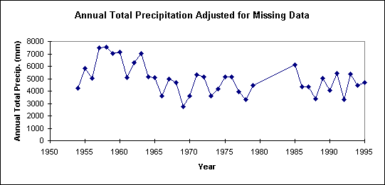
The mean total annual precipitation from the adjusted data is 4960 millimeters, the minimum total annual precipitation is 2760 millimeters (based on nine months in 1969) and the maximum total annual precipitation is 7554 (based on twelve months in 1958). The lowest annual average for a year with twelve months of measurements is 3342 mm in 1992. The mean total precipitation taken for years with twelve months of measurements is 5490 mm (n=13, that is, 13 years are complete between 1957 and 1994).
The total annual precipitation trends downward, but only as an artifact of a period of high precipitation averages in the late 1950's. Data will have to be collected over a longer period of time prior to concluding whether the average annual precipitation is actually decreasing. The rate of decrease as modeled by a linear best fit equation is 40 millimeters per year, but given that this is based on artificially adjusted data the conclusion that precipitation is actually decreasing should not be drawn. Data from the Japanese period would be of valuable assistance in determining precipitation trends.
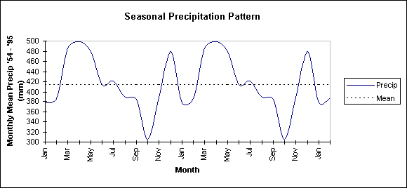
There is a pattern of seasonal precipitation when the monthly means are combined. Between June and early November Kosrae experiences average to below average rainfall. Mean rainfall is higher in December and from March to June. During January and February rainfalls are below average. This pattern may be a result of the Intertropical Convergence Zone (ITCZ) moving southward over Kosrae in November and December, and then moving Northward over Kosrae in March through April. The precipitation spike in late November and early December may also be due to tropical storm systems that form in conjunction with the ITCZ.
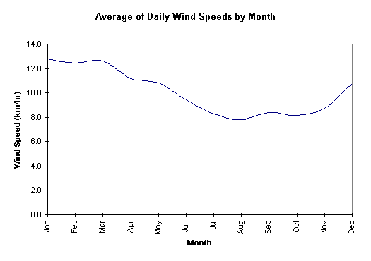
Historical wind data for Kosrae either does not exist or is not available. The data provided is for the island of Pohnpei. The data for average daily wind speeds in Pohnpei is very complete with 4369 daily average wind speed measurements. The average daily wind speed in Pohnpei was 10 km/hr from January 1984 to July 1995. The highest daily average was 34 km/hr on the 18th of May, 1986. Tropical storm strength winds would be 55 km/hr (average over a one minute interval), hence the island of Pohnpei has not had 24 hours of tropical storm strength winds. There is a seasonal variation in the average daily wind speeds with higher than the annual average wind speed from December to May and lower than the annual average from June to November. The longest period of above average winds is an 87 day period from December 1992 to March 1993. While prolonged winds of a given direction across a large enough fetch can affect sea levels in this region, the average daily wind data does not include directional information.
Report written by Dana Lee Ling, Spring 1995.