Fulofol planted in Malem pre-contact?
Friday, July 21, 2006 4:54 PM
I was at a 60th birthday party just
south of Malem here on Kosrae a few weeks ago. As I have done for the
past 14 years, I wandered down to the beach to have a look at the
coast. As I have come to expect to find, where the omp and oa (Ipomea)
are "cleaned" the beach is eroding, where the omp and oa are left alone
the berm is holding together and the beach looks healthier.
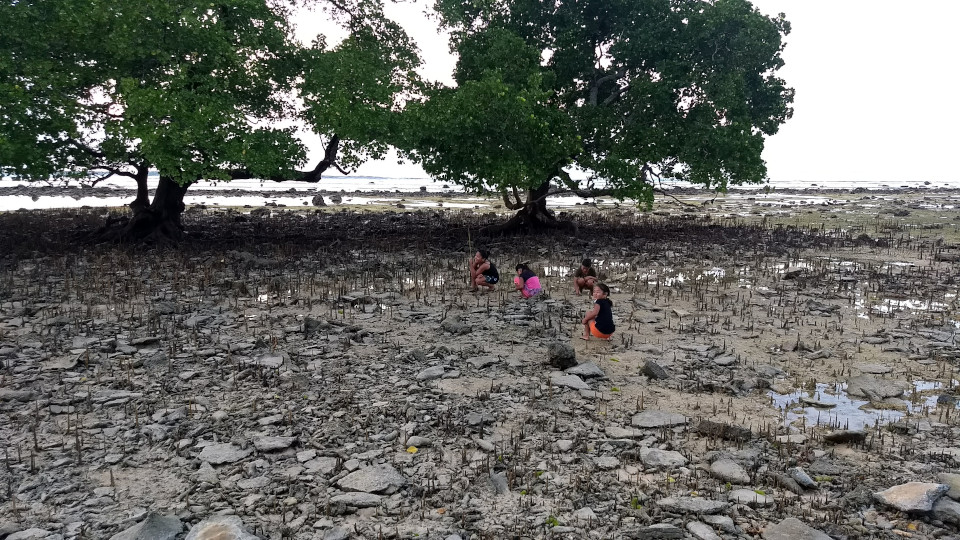
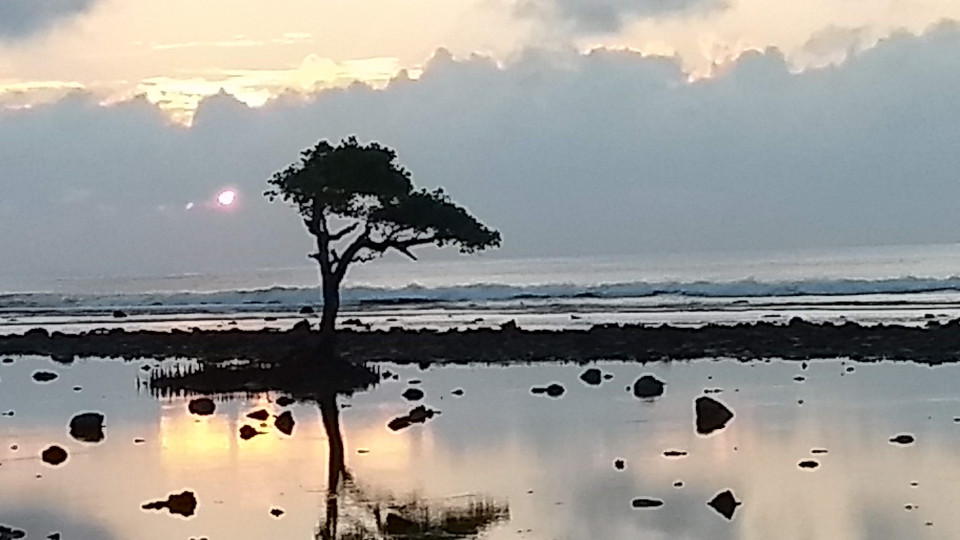
I noticed something else that puzzled me. The fulofol is a) very old b)
dying or dead and c) there are no young fulofol growing. Fulofol is the
mangrove tree with the knees found on the reef here in Malem. Any
natural system usually provides evidence of succession - if the system
is naturally self-renewing. I realize that there are exceptions -
forests in Wyoming that renew only after the pine cones have been
heated by fire.
I am certain I am wrong and surely crazy, but the thought came into my
tiny little head that the fulofol is not native or "natural" to the
reef of Malem. It does not renew itself on the reefs of Malem. Not all
by itself. I asked the newly 60 year-old how old were the fulofol. He
seemed perturbed by my daring to ask him anything, and indicated he did
not know. Although he did not appear to want to discuss the matter, he
indicated that as far as he knew the trees had been there since he was
a child. Another guest noted that as far as they knew those trees were
very old.
I dragged a fellow from Utwe who is my age out to the beach and asked
him where were the baby fulofol, he noted that he had not seen any. Not
out on the reef. He said the waves were too rough for the fulofol to
get started on the reef.
Now I was really troubled - if the reef waves are too rough, how did
the fulofol that is there get there in the first place?
Now I am keenly aware the human brain sees patterns where there are
none, that statistically coincidences happen, and that in any natural
system such as a reef there may be an optimum location for plants to
root and grow. So I am certain I am wrong. Yet I saw something that
puzzled me: the oldest of the fulofol were all in a line. A straight
line.
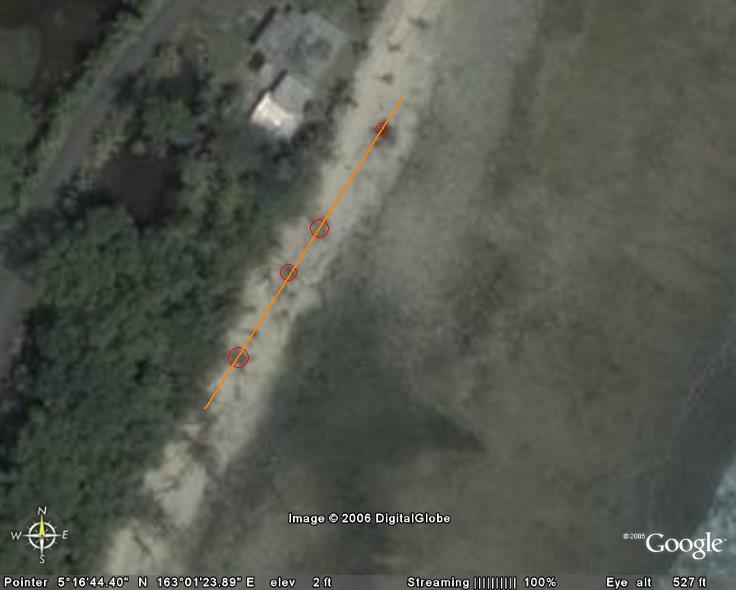
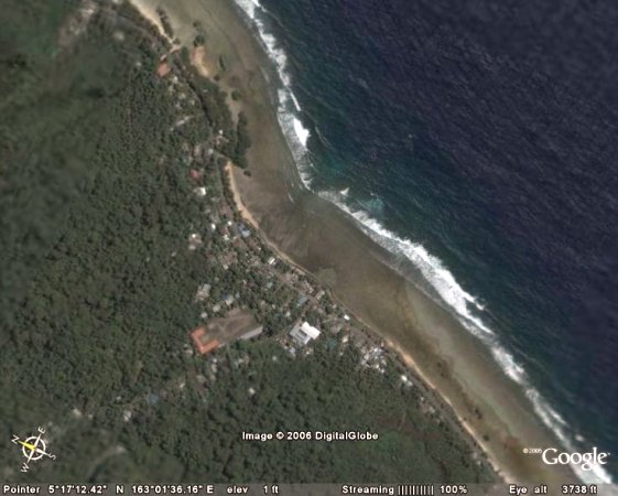
(road on the left, beach is light yellow gray, reef flat is gray, reef
edge wave line on the extreme lower right)
On the way home I gave a ride to an old woman who lives near the Malem
river outlet, next to where old Nena Livaie used to live. I asked her
about fulofol on the reef in Malem and she noted that there used to be
fulofol in front of her house - the fulofol extended up and down the
coast at one time. She noted it was almost all gone now.
Running the other night on the reef at low tide I noticed the same
linear effect just south of the Malem river outlet.

Yes, I know, that may be the location of a minimum in the translating
wave energy on the reef and hence was an optimal location for seedling
growth. Yet there are no new young seedling anywhere along that line.
No new growth.
Up in Piyuul the same situation: no baby trees, no young growth. Just
really old trees.
Now here is the really crazy part of my thinking: what if someone
planted the fulofol? What if there was an optimal time - a window -
every few years in which fulofol could get a start. Those of who surf
know if we are in an El Nino or La Nina just by the depth of the water
on the heads. Shallow in an El Nino year, deep in a La Nina year. Every
few decades a deep El Nino should move lots of water out - providing
for lowish tides even in winter. A chance for fulofol to get started.
On the transition to La Nina the tropical storms form west - as they
have been doing thus far this year. You get a window of opportunity to
get a new batch of shoreline protecting fulofol started.
One only needs to replant every few decades or so - and one only gets
the right combination every few decades or so. Ancient wisdom? Lost
during the population collapse of the late 1800s? Did the ancient
Malemites know that one had to replant fulofol periodically to protect
the coast?
Given that the breakwater has altered the coastal dynamics, could
fulofol even be planted on the reef in Malem to protect the reef?
I note the timeliness of a new UNEP report on the risk to mangroves.
Maybe here in Malem people are the ones who have to be proactive and
plant the trees that protect the coast.
This is by no means any form of
sound analysis. I sure wish we could get a coastal expert in to look at
the coast of Malem and come to understand why it acts and reacts as it
does. Over the years I've heard the moving of the river mouth blamed,
waves blamed, all sorts of reasons for the erosion. And Malem has
turned to a massive breakwater wall to attempt to hold off the ocean.
Yet the waves are already scouring away at the bottom of this
fortification.
Andy George wrote:
Lenwo Dana,
Possible theory, but as far as I
know, the fulofol trees were at one time grown along the banks of the
Malem river/natural drainage which used to run along the shoreline from
Malem to Masis (by the Baptist Church) where it joined in with the
Masis river. The entire segment of the river, however, is gone, due to
erosion. The only remnants of the river are the fulofol trees.
andy
Post-script: I was wrong. Photos taken in 1944
confirm that the trees are a remnant of a line of trees that stood on
the shore line. The photos supplied by Doug Ramsey - which Simpson
indicated he also has copies of - confirm this. That leaves, at least
for me, unexplained as to the why the catastrophic loss of the trees
and thence the shoreline.
The key seems to be the river, and not necessarily the 1950s
straightening of the river. In the 1950s the river mouth was moved
about a hundred meters South, but an informant says the fulofol was
already dying before that move of the river outlet. His understanding
when he was growing up in the late 40s and early 50s was that the Malem
river headed south to Yesing (sp?). He thinks that the river was moved
long before the Japanese arrived on the island. He indicated that an
old riverbed to the south of the present riverbed (just south of Rinson
Phillips home) is the original riverbed and this flow went to Yesing.
That leaves open in my mind that the possibility of a more fundamental
change in hydrodynamics. Up in Piyuul fresh water spring exist on the
reef - artesian springs - that apparently help keep the Piyuul fulofol
alive in some way. Maybe there was artesian pressure under the reef in
Malem that helped maintain the nipa and fulofol that grew along the
shore line. The trenching of the river may have effectively drained the
swamps and removed the pressure that acted as a pump of fresh water
under the strand.
I hope to get a hold of Doug Ramsey and inquire about the extent to
which the 1944 Navy photos can be shared. I think I can share the
following image to help others understand the error of my ways. I have
reduced the image to spare those on dial-up connections. I would do
something fancier with the two images below, but I do not have the
horsepower in my computer to work with large image files.
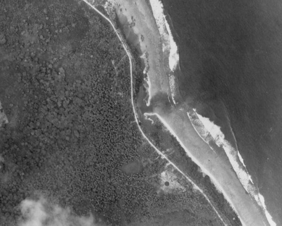
In the 1944 shot above a bomb crater can be seen in what appears to be
the vicinity of the modern Malem church. The road is the Japanese sand,
an informant says the modern road is essentially on top of that road.
Shoreward of what is now the singular main channel is a second outlet
structure. This is a drainage on a large reef pool which my informant
says was like a lake. He noted it was deep and primarily comprised of
fresh water, probably from the river. The river went under the road
near the present bridge and then turned north running oceanside of the
road. The lighter colored vegetation oceanward of the road is possibly
nipa palm, with the fulofol on the inner edge of the sand. Standing on
the road in Malem one could not see through the vegetation to the ocean
- hard to believe nowadays!
Ever since I dropped a tire on a pick-up I was driving off a bridge on
that old riverbed to the south of the present riverbed back in 1993 I
have wondered why that riverbed is there - now I know.
My thanks to Katrina at KVR, Doug Ramsey, Lyndon Cornelius, Andy
George, Bill Raynor, and Takumi George for their assistance and
guidance in correcting my wrong ideas!
Which all leaves me back where my mind started: is there anyway to save
that coastline short of the brute force approach of a massive line of
breakwaters and dikes which require constant repair and renewal? Is
there anyway to keep the remaining fulofol from dying? To get young
growing again? A living breakwater would be at least a partially
self-repairing buffer against the sea.
See also:
Kosrae Coast
Sandy Beach Hotel
Credit for the 1944 aerial photo:
The scanned image used is from a set of aerial images taken
in June 1944 by US spy planes. 22 of the images were obtained by
the US Forestry Service from the Bishop Museum in Hawaii. Reprints
of the originals are held with the US Forestry service in Hawaii
The remainder were discovered in the Kosrae State Survey Department and
were scanned in by the DRC. Due to the limitations of the scanner parts
of some of the photographs were cut off and only the coastal images
were scanned in. However, the aerial images found in the Survey
Department were taken to the South Pacific Applied Geoscience
Commission in Fiji (April 2000) to be scanned in properly.
Doug Ramsay
Coastal engineer
Development Review Commission
April 2000
Remnants of the Sonneratia alba fulolof near the Malem ball field near North 5.280867° East 163.024183° June 8, 2018