 ]
]Due to rain at the start there was no attempt to take cameras up the mountain. The day had been rainy and the mountain was shrouded in fog. Despite a start under rain, the rain stopped as we climbed to the huts at 700 feet. Fifteen started the climb. We left at 2:10 P.M. on 28 November 2000.
By the huts the group was spread out and we regrouped by waiting for ten minutes. At this point there were still two nursing mothers climbing to the 700 foot point, one of whom had previously been on this hike. The group at 700 continued up. The group was already spreading out by the sakau patch gully just past the huts. Climbing out of the gully up the side of the spine the group fell apart further. There still seems to be no way to keep the group together at this point. I would later learn that three people would remain at the 700 foot level.
Chromolaena odorata and Costus speciosus were present in the gully and above the gully. The clearing at 1000 feet has C. speciosus present and in bloom. We removed the plants we could see.
The climax group of students consisted of eight students, Boldon Abraham, Daphne Anson, Robert Churney Jr., John Gelag, Alik Palik, Jansen Santos, Nicholas Victor, Rufino Xavier. For the first time the lead students to the 1250 foot point were men. We also had the lowest number of women to reach the turn-around point in three years of climbing the mountain (one). The top was enveloped in fog.
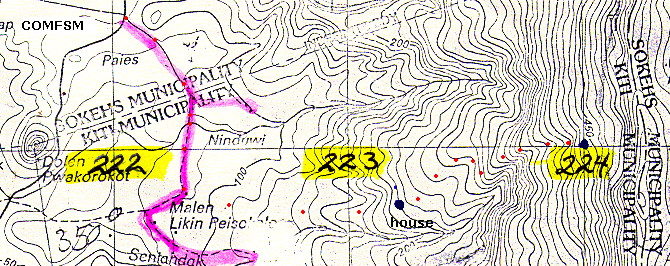
Turn-around was reached at 3:15 at what we identified last year as grid point 224 at 1250 feet above sea level, with actual descent beginning closer to 3:30. The tail took its time coming down, looking at Alpinia carolinensis (ieuieu), filmy ferns, Lycopodium phlegmaria (limpahr), Selaginella spp. and other plants.
We heard rain below us, but the topmost group did not get rained on during the ascent out of 700 nor on the return to campus. The descent was not as difficult as last year, the slope was not as slick. Descent still took ninety minutes for the tail due to the group taking its time and enjoying the scenery. The fog lifted from the mountain and we could see Pakin. The 2:00 class time allowed us to be more relaxed about coming off the mountain.
Images of the plants can be seen on last year's page: The mountain 1999
[]
On the map the red dots represent the aproximate path of the hike. The house is marked by dark blue dot, the hike reached grid 224 marked by another dark blue dot.